Navigation and Content
LEO satellite
Innovation

How LEO satellites will elevate logistics

Satellites in low earth orbit (LEO) are poised to deliver high-speed internet connectivity to even the remotest areas – a key to modern digital supply chains. The impact on earth-bound logistics could be quite simply out of this world.

Low earth orbit satellites provide new eyes in the sky

The most successful supply chains of today are digital and visible. Backed by advanced transport and warehouse management systems, they harness the vast Internet of Things (IoT) to track goods tagged with smart sensors across the entire supply chain – from procuring the raw materials to delivering the finished product and everything in between.

But the real key to digital supply chains is connectivity. A surprising 80% of Earth’s surface remains outside cellular network coverage, including most of the high seas and many parts of remote overland trade routes. Some 450 million people on our planet are also disconnected from mobile networks. This can create gaps in supply chain visibility.

Enter low earth orbit satellites or LEOs. They have the potential to deliver high-speed internet  access with a low signal transfer delay, or latency, to the remotest regions on Earth. And LEOs could even be leveraged to establish Bluetooth connections between Earth and space!

Let’s take a closer look.

As the world turns

80%

Portion of Earth’s surface with no cellular coverage

450 million

People today with no mobile connectivity

160–2,000 km

Altitude range of LEOs above the Earth’s surface

2–27 milliseconds

Latency range of ground-to-LEO communication

What are LEO satellites?

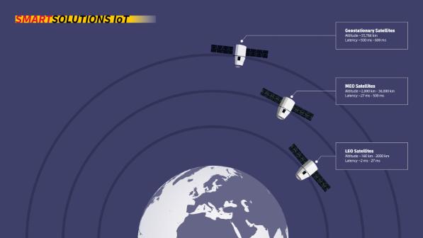
Low earth orbit satellites are precisely that: satellites that orbit the earth at relatively low altitudes of 160 to 2,000 kilometers, completing one revolution in as little as 90 minutes. This sets them apart from their higher-flying counterparts in medium earth orbits (MEO) of 2,000–36,000 km or geostationary earth orbits (GEO) of approximately 36,000 km. Their low orbit allows LEOs to communicate with ground-based equipment with a low latency of just 2–27 milliseconds – a time lag comparable or even superior to some land-based connections.

An infographic titled “Smart Solutions IoT” displays three types of satellites orbiting Earth at different altitudes. The image shows Earth at the bottom with three satellites positioned at varying distances, each with concentric circles representing their orbits. The satellites are labeled: “Geostationary Satellites” at an altitude of approximately 35,786 km with a latency of 500 to 600 milliseconds, “MEO Satellites” at an altitude of 2,000 to 36,000 km with a latency of 27 to 500 milliseconds, and “LEO Satellites” at an altitude of 160 to 2,000 km with a latency of 2 to 27 milliseconds.

How do LEO satellites work?

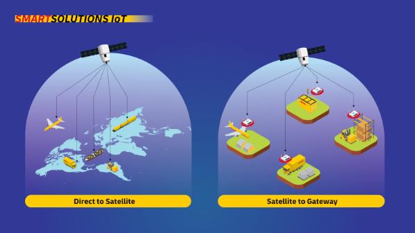
LEO satellite networks communicate with land-based IoT devices either directly or through gateways. They use smaller antennas and require less power, making them cheaper to deploy and operate and allowing for shorter launch-to-operation timelines. Positioned in regions with generally less space debris, LEO satellites are less susceptible to interference, further enhancing their reliability.

That said, it’s important to note that connectivity only works with a direct line-of-sight connection. Receivers installed in assets on Earth would need a direct connection with the satellite to communicate.

Still, LEOs promise to be an attractive solution for providing broad “eyes in the sky” coverage.

An infographic titled “Smart Solutions IoT” illustrates two methods of data transmission in logistics using LEO satellites. The left side is labeled "Direct to Satellite" and shows a satellite directly communicating with a plane, ship, truck, and warehouse over a world map. The right side is labeled “Satellite to Gateway” and shows the satellite transmitting data to gateway devices at different logistics points, including a plane, a storage facility, a truck, and a warehouse with forklifts.

What are LEO satellites used for?

Use cases of LEO satellites span the domains of energy management, forestry and agriculture, and transportation and logistics. Let’s look at a few examples:

Use case 1: global internet connectivity

LEO satellites can bring low-latency, high-bandwidth internet connectivity to remote parts of the planet that have never been connected. Delivering global high-speed internet is the primary use case for LEO satellites – and the prerequisite to all the other use cases below. The SpaceX subsidiary Starlink, founded in 2019, leads the market in space-based broadband with over 6,200 LEOs deployed and 2.6 million customers as of July 2024. Amazon’s Project Kuiper plans to compete with Starlink by deploying over 3,200 LEOs by 2029.

Use case 2: urban planning

The World Bank estimates that 56% of the world’s population now lives in cities. That figure is expected to rise to 70% by 2050 and can only go up from there. LEO satellites have been used for years to track this unrelenting global trend toward urbanization. Having this kind of up-to-the-minute data has been critical for urban planning and will become even more essential as cities become smarter. Higher data speeds will be needed so enable the transformation to smart cities and LEOs will play a key role in making that happen.

Use case 3: smart agriculture

In conventional farming practices, up to 30% of irrigation water typically evaporates or drains away, while up to 50% of fertilizer ends up polluting our waterways rather than enriching the soil. In a world where fewer farmers must produce more food for a growing global population, we cannot afford such inefficiency – not to mention the accompanying environmental degradation. LEO satellites can gather vast amounts of data from weather stations, aerial drone imaging, and IoT networks of soil, livestock, temperature, and water flow sensors, then crunch this data with the help of AI and machine learning tools to optimize irrigation and fertilization, boost crop yields, and minimize environmental impact.

Use case 4: disaster response

When natural disasters strike, land-based communications infrastructure is often disrupted, overburdened, or even destroyed. LEO satellites can keep emergency management authorities and response teams connected, enabling hospitals, emergency services, and rescue efforts to monitor the situation, broadcast public service announcements, and coordinate evacuation routes in the immediate aftermath of the disaster, which is the most critical time.

Use case 5: logistics

The aviation and maritime sectors rely on LEO satellites for support with communication and navigation. Real-time fleet and cargo tracking, global coverage, improved efficiency, and enhanced security are just some of the benefits here. Below we outline more potential logistics use cases.
Want it Delivered?

Why go looking for the latest logistics trends and business insights when you can have them delivered right to you?


JOIN OUR JOURNEY INTO THE FUTURE

Follow us on social and be the first to know the latest logistics innovations and trends.

LEOs and logistics

Dive deeper and the list of applications for LEOs in logistics seems endless. Here are just a few:

  • With more global coverage, we can track assets and shipments in remote areas, which increases end-to-end supply chain visibility.
  • LEOs can keep our hubs online when land-based communications go down, avoiding the massive disruption that would occur if one of our warehouses goes offline.
  • We need connectivity with immediate response times as we deploy more AI-powered solutions. LEOs can deliver the low latency needed for high-speed data transfer.
  • Broader coverage and faster speeds will allow us to monitor the well-being of our people making deliveries in remote or dangerous locations.
  • The increased quality of connectivity will also boost the power of our internet of things, allowing us to quickly detect left, for example, and recover the asset.
ISS

Next-Generation Connectivity

Evolutionary communication and connectivity technologies are poised to leverage LEO satellite networks to bridge the digital divide, providing internet access to remote and underserved regions. Learn more about this important trend and its impact on the future of logistics.

Published: August 2024


Want it Delivered?

Why go looking for the latest logistics trends and business insight?

Subscribe to the monthly newsletter distilled into one digestible package.


Related stories